|
|||
|
|
Chapter 5 APPALACHIAN CINCINNATI
Introduction The term Appalachian is not synonymous with poverty. The vast majority of Appalachians in the metropolitan area are not poor, not on welfare, and are not high school dropouts. Most own their homes and have relatively stable families. They are a predominantly blue collar group. About 10 percent hold managerial and professional jobs. In socioeconomic status white Appalachians, as a group, hold a position between non-Appalachian whites and African Americans. In inner city Cincinnati (and probably Covington and Newport), however, Appalachians in some respects hold a socioeconomic position closer to African Americans than to non-Appalachian whites. African American Appalachians tend to blend into the larger African American community and so are not identifiable in the type of analysis offered here. Other studies show them to be about 16 percent of the Appalachian populations in Cincinnati(1).
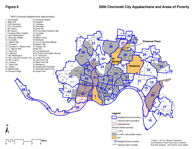
Figure 6 shows the relationship of Appalachians to poverty. Only one Appalachian neighborhood, Carthage, does not have a high poverty rate (see also Chapter 4 on white poverty).
In addition to the areas mentioned in Cincinnati there are many Appalachian sections beyond the city limits - Norwood, Covington, and Newport for example. Clermont county is an Appalachian county. South Lebanon, Western Hamilton County and Dearborn County also have Appalachian concentrations for example, in Harrison and West Harrison.
In many ways white Appalachians and African Americans are in comparable positions regarding socioeconomic status. This can be seen visually by examining figure 6. The SES I and II areas along Millcreek and to the West, excepting North Fairmount, South Cumminsville, and Fay Apartments, are Cincinnati's major Appalachian communities. The SES I and II areas east off I-75, excepting East End, tract 54 in Oakley, Linwood, and census tract 10 in Over-The-Rhine, are primarily African American. (The separately incorporated communities of Elmwood Place and Norwood are east side communities with Appalachian blue collar areas). As African Americans and Appalachians spread out from the inner city their movements have been, respectively, north and east and north and west.
The ecological parallelism breaks down when one notes that there are some high SES primarily African American neighborhoods which have no counterpart white Appalachian areas. These are in Kennedy Heights, North Avondale - Paddock Hills, and Roselawn. High status Appalachians do not concentrate in ethnic enclaves. The parallelism breaks down in other important ways. White Appalachians do not face racial discrimination but may face discrimination based on accent, place of residence, or life styles. White Appalachians without these identifiers may pass easily through doors closed to people of color. White Appalachians, on the other hand, lack the strong organizational infrastructure provided by African American churches and antipoverty agencies set up in response to the civil rights movement. White Appalachians are especially disenfranchised when it comes to the operation of public school systems. This shows up in extremely high dropout rates (see chapter 6).
Defining Appalachian One of the concerns describing Appalachian neighborhoods in Cincinnati is the problem of identifying them. In the 1960s most Cincinnatians probably thought that Appalachians lived in Over-The-Rhine and knew little beyond that. Over the years the list expanded to include Lower Price Hill, Northside, Camp Washington, East End and several other city neighborhoods. (By 1980, Over-the-Rhine was primarily African American.)
In The Social Areas of Cincinnati, Second Edition (1986) a set of criteria was defined and a formal list of Appalachian neighborhoods was developed. These criteria have been revised for this edition and are displayed in Table 5a and include the percent below poverty, percent of African American population, high school dropouts, joblessness rate, occupational status and family size.
Table 5a Criteria For Classifying Neighborhoods as Appalachian 1. Greater than 16% of the families were below poverty level 2. Less than 39% of them are African American 3. Less than 76% of the persons 25 and older persons are high school graduates 4. More than 15% of the persons 16-19 years old who are not in school, are not high school graduates. 5. More than 31% of the persons 16-19 years old are jobless (persons unemployed plus persons under 65 years not in the civilian labor force). 6. More than 3.1 persons per family
If a community met six of the seven criteria, it was considered to have a majority of Appalachian population. If at least four criteria were met, the neighborhood was identified as having a significant Appalachian population, but not as long as the African American population was more than 42.8 (the city wide) percentage.
Starting with a list of neighborhoods created from this criteria, in 1996 Fred Hoeweler updated the list using the same criteria and applied them using block group data from the 1990 census. The Hoeweler version of the 1986 Maloney/Heller list deleted Oakley and added East Price Hill. For the present edition, Christopher Auffrey deleted the occupational index from the criteria and derived a list of neighborhoods which met at least four of the six remaining criteria. They are Camp Washington, Carthage, East End, East Price Hill, Linwood, Lower Price Hill, Northside, Riverside - Sayler Park, Sedamsville - Riverside and South Fairmount. All together ten neighborhoods are considered Appalachian (Table 5b). The authors acknowledge the circular reasoning involved in using these negative criteria to define Appalachian neighborhoods. We can say minimally that Cincinnati's Appalachian leaders concur that these are Cincinnati neighborhoods with high percentages of people of Appalachian origin.
Table 5b Cincinnati Neighborhoods with Appalachian Census Tracts, 2000*
* Met at least 4 of the 6 criteria for classifying census tracts as Appalachian, with African American less than citywide mean of 39 percent.
Overall Trends, 1970, 1990, and 2000 Tables 5c and 5d present neighborhood indicators from 1970, 1990 and 2000. This comparison allows us to make conclusions regarding Cincinnati's Appalachian neighborhood changes during this period. Before looking at socioeconomic indicators, we will look at the population of these areas. The first conclusion is that all neighborhoods except Riverside - Sayler Park lost population. This is not surprising. During the same period the City of Cincinnati lost 122,000 people. The most severe losses in percentage terms were in Lower Price Hill, the East End, South Fairmount, Camp Washington, and Sedamsville - Riverside. These lost about half of their respective populations. Northside and East Price Hill also had heavy losses in terms of total numbers if not percentages. Between 1970 and 2000, six of the neighborhoods gained in SES and four declined. Camp Washington's SES index moved up by eleven points in relation to other neighborhoods. Its apparent improved status is believed to be a by product of even more severe decline in surrounding Mill Creek communities such as Millvale. The East End also experienced a gain in SES, mainly in the past decade. During this period there was further displacement of low-income people and gentrification. In 1990, 82 percent of the children under 18 in the East End lived in two parent homes. In 2000 this has fallen to 25 percent. Sedamsville - Riverside's SES index also decreased and the neighborhood maintained its family status indicator at 58 percent. Riverside - Sayler Park experienced big gains in the seventies and has remained at the same level since then. See Appendix III for SES changes in these and other neighborhoods. See Appendix II for the 2000 scores and ranks on the five individual variables that comprise the SES index.
During the 1980s poverty increased dramatically in Ohio's metropolitan centers. In Hamilton County the increase was 18 percent. In inner city neighborhoods the increase was even higher than in the county as a whole. Deindustrialization, migration of jobs to suburbia, and the shift to lower paying service jobs are all believed to be factors in the increase of poverty. The failure of urban school systems is perhaps closely related to these economic transitions. Poverty rates doubled in several Cincinnati Appalachian neighborhoods, increased in all of them, and tripled in East Price Hill. In South Fairmount the poverty rate went from 13 percent in 1970 to 24 percent in 1990. Poverty in Camp Washington also increased considerably. (For 2000 trends see Working Class White Areas in Chapter 4. Analysis of the components of change in the other Appalachian neighborhoods makes clear that a decline in family status indicator is significant. This seems to be related to poverty status. The neighborhoods which experienced the greatest increases in poverty tended also to be the ones with the greatest declines in family status. The unemployment rate (table 8a) does not as clearly seem related to a decline in family status or SES. Table 5c Cincinnati Appalachian Neighborhood Populations, 1970-2000
Table 5d Socioeconomic Indicators: Cincinnati Appalachian Neighborhoods, 1970-2000
|
||||||||||||||||||||||||||||||||||||||||||||||||||||||||||||||||||||||||||||||||||||||||||||||||||||||||||||||||||||||||||||||||||||||||||||||||||||||||||||||||||||||||||||||||||||||||||||||||||||||||||||||||||||||||||||||||||||||||||||||||||||||||||||||||||||||||||||||||||||||||||||||||||||||||||||||||||||||||||||||||||||||||||||||||||||||||||||||||||||||||||||||||||||||||||||||||||||||||||||||||||||||||||||||||||||||||||||||||||
![[Image: Compass Rose]](/art/CompassRoseSmall.jpg)