|
|||
|
|
Chapter 10CINCINNATI AS A METROPOLIS
Most of this report has focused on Cincinnati as a city. Social problems, however, are not confined to the central city. In this section the focus is on Cincinnati as the central city of a seven county metropolitan area, the Cincinnati, Ohio - Kentucky -Indiana Standard Metropolitan Statistical Area (SMSA or SMA). It should also be pointed out that Cincinnati has now achieved the status of a Consolidated Metropolitan Statistical Area (CMSA) which includes the seven counties plus the newly recognized Hamilton-Middletown Metropolitan Area. Cincinnati is one of the first six CMSA's to be recognized by the Census Bureau. More recently, the Cincinnati Primary Metropolitan Statistical Area (PMSA) has been expanded to include the seven counties plus Brown county in Ohio, Ohio County in Indiana, and Gallatin, Grant, and Pendleton in Kentucky. In order to maintain consistency with 1980 edition these new counties are not included in this study.
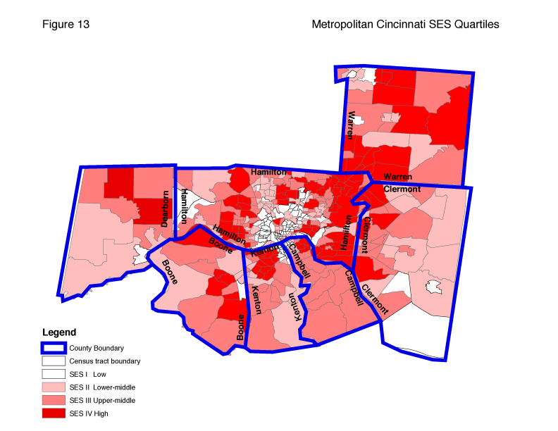
Figure 13 shows Cincinnati's social areas as part of the broader social area scheme of the metropolitan area (SMA). The following is intended as only a preliminary thumbnail sketch of the four social areas of metropolitan Cincinnati. The purpose of including this reference to metropolitan area analysis is to encourage planners of human services to intensify their efforts to look at needs in a regional context. In the metropolitan area there are numerous agencies which should be able to utilize social areas data in needs assessments and priority setting. The Community Chest, for example, is organized on a regional basis and needs data that are comparative across jurisdictional lines. Inquiries for further analysis may be directed to the authors.
Describing the Four Areas SES I (lowest SES) in a metropolitan context appears primarily as a series of low income enclaves along the various rivers (Ohio, Little Miami, Great Miami, Licking) and streams (Mill Creek). A second set of these enclaves extend from Cincinnati's Over-The-Rhine neighborhood, north to Lincoln Heights and Woodlawn. A third extends from Over-the-Rhine Northeast along Reading Road and Montgomery Road to Norwood and St. Bernard. The core of the low SES area is the area surrounding Cincinnati's Central Business District (CBD) including low lying sections of Covington and Newport, Kentucky, and the front of Cincinnati's western plateau. Suburban enclaves of SES I are rare but include an area of Lincoln Heights, Woodlawn, and Sharonville in the north of Hamilton County. Beyond
suburbia, there are two SES I tracts in Hamilton and Whitewater townships on the Indiana boarder, one tract in Dearborn County, one in Boone, three in southern Clermont, and three and Warren County to the west and northwest. One of the Warren County tracts contains two prisons and the other two are in Franklin Township. In terms of race and ethnicity, SES I consists of a variety of African American and white Appalachian enclaves. Several of these, including Cincinnati's Over-The-Rhine and Northside areas, are interracial communities.
SES II includes heavily African American and Appalachian 'second stage' neighborhoods in the heart of the metropolis and large sections on the rural periphery or exurbia. The southern half of Dearborn County, three scattered pockets in Warren County, and north eastern Clermont County are a part of this area.
SES III is similarly arranged and includes scattered sections of the central city's area, most of Warren County, and huge sections of the other six counties. The two largest areas are in Campbell and Kenton Counties.
SES IV includes the Cincinnati neighborhoods of Clifton, Mt. Adams, the Hyde Park area, and one tract in the CBD and then moves out to form an almost complete circle around Cincinnati, Covington and Newport. The Northern Kentucky communities of Fort Thomas, Fort Mitchell, and Highland Heights but none of Covington, Newport, Dayton, and Belleview are a part of this highest SES area.
The Changing Shape of Metropolitan Social Areas Between 1980 and 1990, SES IV moved further west in Hamilton County, filling in most of the area immediately east of the Great Miami. In Boone County, a new SES IV area emerged in the East Central area. SES IV areas in Clermont and Warren Counties expanded dramatically. These changes reflect a trend toward the growing movement of more affluent people to the outer suburbs and beyond. In the 1980s, the trend continued and Dearborn County saw two of its tracts move up to SES IV. SES IV expanded significantly in Boone County but not in Kenton and Campbell.
The same trend is possibly the reason that the large SES I areas on the rural periphery (see Figure 2 of Second Edition compared to Figure 13 of the current edition) virtually disappeared between 1980 and 2000. These areas are now primarily SES II or even III.
Table 10a Metropolitan Counties, their Census Tracts and SES Indices, 2000
*The percentages are the percent of census tracts in each county per quartile SES Areas by CountyTable 10a provides the SES Index for the metro census tracts by county. An average SES Index is also provided for each county. Individual tract indexes (Appendix IV) show the great gap between inner city and most suburban areas. The lowest tract Index in Boone County is tract 703.01 with an index of 92.2. The SES index for tract 501 in Newport (Campbell county), by comparison is only 31 which is similar to the low SES tracts in Cincinnati. The range is between tract 6.07 which has an index of 51 and tract 36.2 with an index of 347.6. In Clermont County the range in SES Index is from 111 (tract 418) to 316.6 (tract 404.02). In Dearborn County tract 805 has an index of 115.4 and tract 802.01 an index of 296.2. Dearborn County has only one tract in SES I. Boone County also has one. Campbell County which includes Newport has seven. Kenton County, including Covington has eleven. Warren County has 2 tracts, and Hamilton, 71 in SES I (ten more than in 1990). Table 10e shows income and poverty statistics for all seven counties. In 1990, Hamilton County had the third highest overall income in spite of having the highest poverty rate. In 2000 it had the fifth highest. Warren County had the highest median family income and lowest poverty rate in both decades.
A glance at the list of tracts by county reveals that low SES concentrations are primarily in Hamilton and secondarily in Kenton, Campbell and Clermont counties. The inner city areas of Cincinnati, Covington and Newport can be viewed (figure 13) as one contiguous social area primarily made up of SES I tracts. This pattern is broken somewhat by the high SES tracts in the CBD, Mt.Adams, East Walnut Hills, Hyde Park and the area around the University of Cincinnati. These data clearly support the notion that problems of the central city cross county and state lines and should be viewed in a metropolitan context as we look for solutions. One of the first issues to challenge regional cooperation is transportation planning. Will new mass transit plans help inner city residents get to jobs in suburbia or will they focus on intersuburban routes? The latter focus will continue the disabilities of inner city residents and contribute, according to Rusk and other urban experts, to eventual regional decline.
SES by Tract in the SMSA Appendix IV lists all the census tracts in the old seven county SMSA. Appendix IV can be used to look at the individual components of SES. If the reader wishes to know, for example, the census tracts with the worst overcrowding a glance at the overcrowding column will reveal that tract 10 in Hamilton county is the most overcrowded, tract 9 has the second worst crowding, etc.
The right hand column for overcrowding gives the rank. The left hand column gives the score expressed as a percentage of households having more than one person per room. See variable descriptions in chapter 1. After looking at all five SES ranks and scores for a given tract one can, see for example, that tract 91 gets its low SES rank (10th from the bottom) primarily because of its education and crowding indicator ranks, as ranks on the other variables are considerably higher. The State of the RegionDoes Cincinnati retain its 'integration potential' as claimed in previous editions of this study? As was the case in 1980, the core cities of the metropolis - Cincinnati, Covington, Newport, Dayton, and Belleview were primarily in SES I and II. Although these lower SES areas expanded somewhat during the decade, especially on Cincinnati's west side, there were some hopeful signs too. First, there remains some high SES (III and IV) areas in the central city (Figure 13) and these areas are not isolated from but are adjacent to, lower SES areas. Second, much of the high SES area remains within Hamilton County and much of the high SES part of Kenton and Campbell Counties is adjacent to the inner city. Third, the news regarding racial change is not entirely negative. Within the city of Cincinnati, some neighborhoods have been able to increase the degree of racial integration, for example, Corryville and Evanston - East Walnut Hills. Others, like Mt. Auburn have been able to stem white flight before they became one race communities. Several communities such as Northside have remained remarkably diverse. In 1970, Cincinnati was 27.7 percent African American. In 2000, it was 42.8 percent African American. In 1970, 77 percent of Cincinnati's African Americans lived in SES I and II. In 1990, that figure was down slightly to 65 percent. There is clearly a need for more progress in racial integration.
Socioeconomic integration is also lacking. High status areas in the suburbs remain segregated by class as well as by race. SES IV in the metropolitan area (Table 10b) is 98 percent white or other – up one percent from 1990. SES IV in the metropolitan area has a 4 percent poverty rate compared to 8 percent in Cincinnati's SES IV. Inequality between the central city and its suburbs is relatively new and not to be taken for granted. According to data assembled by David Rusk, an urban analyst, "in 1950 Cincinnati household incomes were equal to household incomes in the region(1). By 1990, Cincinnati household income was 76 percent of the average regional household income. Meanwhile the regional poverty rate rose slightly from 10.6 percent to 11.4 percent from 1970 to 1990. By contrast, Cincinnati's poverty rate doubled from 12 percent to 24 percent in the ten year span between 1980 and 1990(2)." Rusk and other urban experts believe that unless the growing inequality between central cities and suburbs is halted through regional cooperation in planning and public policy, Cincinnati will join the ranks of declining regions. According to Neil R. Pierce the need for regional cooperation is to resolve three issues (1) the social and economic chasms between the advantaged and disadvantaged (2) unchecked urban sprawl and (3) the lack of coherence in metropolitan governance (op. cit, p. 6-7). Table 10b City of Cincinnati and Remainder of Metropolitan Area* Demographics by SES Quartile, 2000
The latter includes the capacity to develop long range plans in such areas as jobs, education, housing and transportation.
Cincinnati Metro And City Comparisons Tables 10b, 10c, and 10d can be used to make comparisons between the city of Cincinnati and the seven county area as a whole. We can see, for example, that the percentage of single family homes in the metro area as a whole is much higher than that for the city. In SES IV (city area) the percent of single family homes is 48.9 percent, while a rate almost twice as high (84.3%) is found in SES IV in the metropolitan area. Table 10b also shows that the degree of racial segregation is even more extreme in the metropolis than in the core city. For example, in the city SES IV is 12% African American. In the remainder of the metropolitan area, African Americans are only 5 percent of the population in SES IV. The African American population is radically different in sections of the metro area outside the City of Cincinnati. The great majority of non-Cincinnati African Americans live in SES III areas. Only 5,684 (6%) of non-Cincinnati blacks live in SES I. This compares to 95,211 (94%) who live in SES I in Cincinnati. The authors find this both comforting and disturbing. The disturbing part is the idea that the development of working class residential areas outside the central city has been restricted. The concentration of poverty in the city is not quite as extreme by comparison to racial segregation. Whereas 73 percent of the Metropolitan area's African American population lives in the city only 53 percent of the poor live in the city (see table 10d). Not even half of those receiving public assistance live in the city, but the rate of poverty is much higher in the city.
A look at the distribution of the elderly population in the table 10b shows that SES III and SES IV in the city are the areas with highest percentages. The highest percentages of the youth (under 16) show up in SES I (Table 12b). Unemployment rates are highest in SES I and II in the city. In the two upper SES quartiles there is less difference in the unemployment rates between the city and the metro area. In all four quartiles there is a significant income gap between the city and metropolitan area. A similar pattern is evident when city and metro are compared on the Family Structure Indicator. The gap on this indicator is extreme. In the metropolitan area's SES IV over 90 percent of children under 18 live in two parent homes. The occupation indicator does not discriminate as clearly between the various social areas and between metro and city. The Education Indicator shows a gap between the various quartiles but not so much between the city and metro. In SES I City 53 percent of adults (over 25) have less than high school education. In SES I Metro the Education Indicator is 47 percent. Overcrowding rates in the city are not quite double those in the metro area as a whole. Note: In all the above examples and in table 12a the figures for the metro area do not include the data from the city of Cincinnati.
Table 10c Comparison of Average SES Indicators by SES Quartiles, City of Cincinnati and Remainder of Metropolitan Area*
Table 10d City of Cincinnati as Percent of Metropolitan Area Totals, 2000
Table 10b shows that in 2000 21 percent of the Metropolitan area population lived in Cincinnati, 15 percent of the families, 74 percent of African American population, 46 percent of poor families and 21 percent of persons over 60 years of age.
Table 10e looks at poverty and female headed households. Most of the families below poverty live in Hamilton County. Kenton County comes in second. The more rural Dearborn and Boone Counties have relatively few families in this category. Campbell and Kenton Counties have poverty rates close to that of Hamilton County (8.8).
Table 10f examines the distribution of the African American population in the seven counties. None of the counties except Hamilton had a 2000 African American population that exceeded 4 percent. Most of the seven counties had a African American population of 2 percent or less.
Table 10g shows the education statistics for the region. There is not a wide range among the counties on any of the three education variables when percentages are used. The raw numbers do show a great difference. Hamilton County, for example had 94,207 individuals with less than a high school education compared to 6,454 in less populous Dearborn County.
Table 10h looks at joblessness and unemployment. Not surprisingly Hamilton County had the highest 2000 unemployment rate. Campbell County was next at 3.9 percent. Joblessness is also most severe in Hamilton county with Warren in second place. By far the greatest numbers (as compared to percentages) of jobless and unemployed live in Hamilton County, of course.
Table 10e Metropolitan Family Incomes and Families Below Poverty, 2000
Table 10f Metropolitan Area Distribution of African American Population, 2000
Table 10g Metropolitan Area Adult Education levels, 2000
Table 10h Metropolitan area Joblessness and Unemployment Rates, 2000
|
|||||||||||||||||||||||||||||||||||||||||||||||||||||||||||||||||||||||||||||||||||||||||||||||||||||||||||||||||||||||||||||||||||||||||||||||||||||||||||||||||||||||||||||||||||||||||||||||||||||||||||||||||||||||||||||||||||||||||||||||||||||||||||||||||||||||||||||||||||||||||||||||||||||||||||||||||||||||||||||||||||||||||||||||||||||||||||||||||||||||||||||||||||||||||||||||||||||||||||||||||||||||||||||||||||||||||||||||||||||||||||||||||||||||||||||||||||||||||||||||||||||||||||||||||||||||||||||||||||||||||||||||||||||||||||||||||||||||||||||||||||||||||||||||||||||||||||||||||||||||||||||||||||||||||||||||||||||||||||||||||||||||||||||||||||||||||||||||||||||||||||||||||||||||||||||||||||||||||||||||||||||||||||||||||||||||||||||||||||||||||||||||||||||||||||||||||||||||||||||||||||||||||||||||||||||||||||||||||||||||||||||||||||||||||||||||||||||||||||||||||||||||||||||||||||||||||||||||||||||||||||||||||||||||||||||||||||||||||||||||||||||||||||||||||||||||||||||||||||||
![[Image: Compass Rose]](/art/CompassRoseSmall.jpg)